Mexico City's Sinking Crisis: How Groundwater Extraction Causes 14 Inches of Subsidence Annually
The Alarming Scale of Subsidence
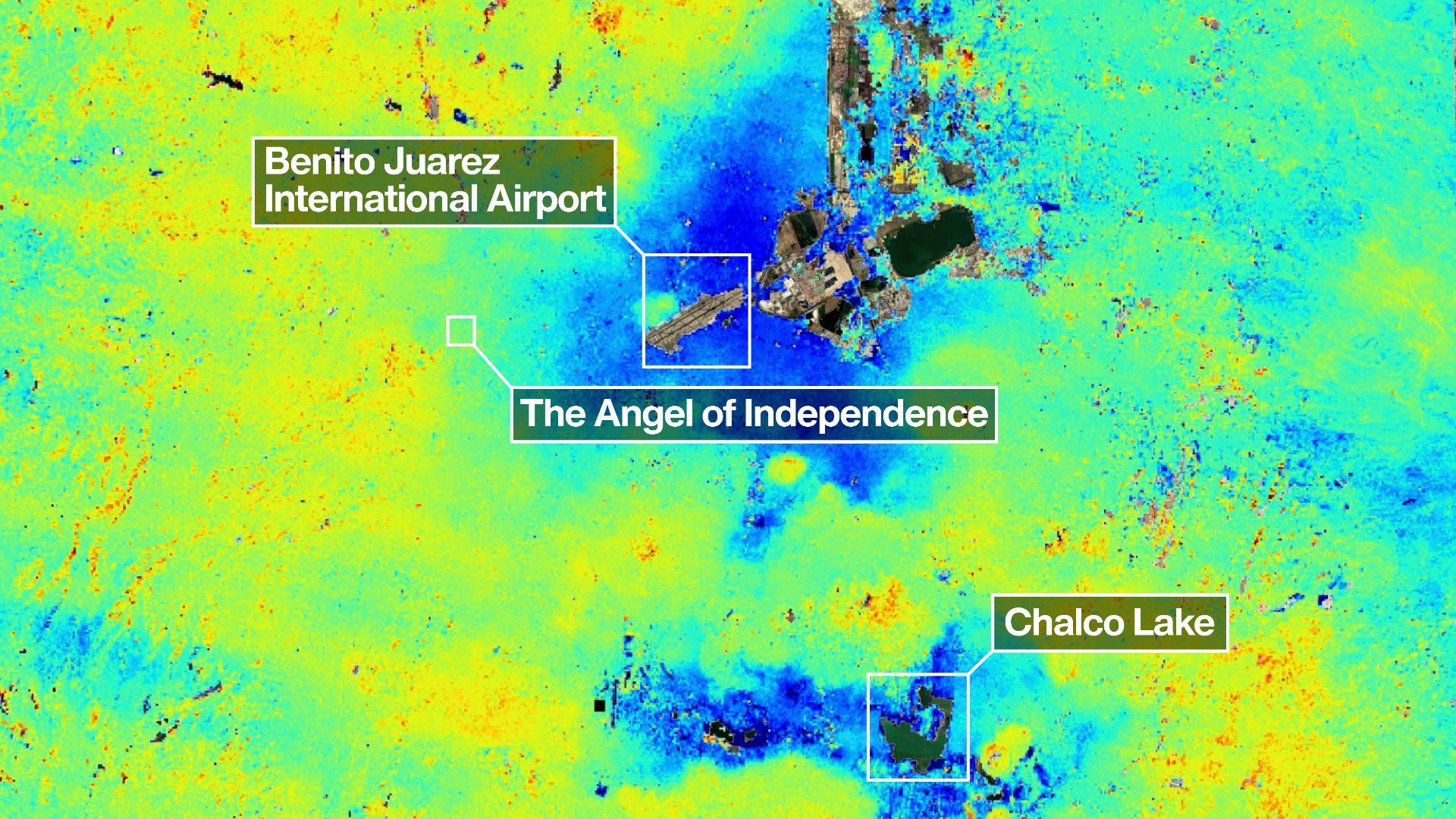
Mexico City is experiencing one of the most dramatic land subsidence events on the planet. New satellite imagery confirms that parts of the metropolis are sinking by as much as 14 inches (35.5 cm) every year. This rapid drop, detectable from space, poses a growing threat to infrastructure, water systems, and the daily lives of millions.

What Satellite Images Reveal
Analysis of high-resolution satellite radar data, particularly from ESA's Sentinel-1 mission, shows that the subsidence is not uniform. Some neighborhoods in the historic center and eastern districts are sinking faster than others. Over the past decade, certain areas have dropped more than 40 feet (12 meters), making Mexico City one of the fastest-subsiding urban centers worldwide.
Why Is Mexico City Sinking So Fast?
Geological Legacy: Built on a Lake Bed
The primary cause lies beneath the surface. The city was founded on the drained lakebed of Lake Texcoco. The soil consists mostly of soft clay—highly compressible and saturated with water. When water is removed from this type of sediment, the clay particles compact, causing the ground to lower.
Groundwater Overexploitation
To meet the water demands of over 20 million residents, authorities pump enormous volumes of groundwater from the ancient aquifer underlying the city. The extraction rate far exceeds natural recharge. As the aquifer is depleted, the pore pressure drops, and the sediments above compact irreversibly. This combination of soft lake sediments and relentless pumping drives the rapid sinking.
Consequences of Sinking Ground
Infrastructure Damage
Differential subsidence—where some areas sink faster than others—causes severe stress on buildings, roads, and pipelines. Historical structures in the city center have tilted or cracked. The iconic Metropolitan Cathedral, for instance, has sunk unevenly, requiring ongoing reinforcement. Underground water and sewer pipes break frequently, leading to leaks and costly repairs.
Increased Flood Risk
As the land lowers, it becomes more prone to flooding. The drainage system, originally designed for a different topography, now struggles to channel stormwater. Neighborhoods in the lowest-lying zones experience more frequent and deeper inundations, especially during the rainy season.
Mitigation Efforts and Future Outlook
The government has attempted to reduce groundwater extraction by importing water from distant sources and promoting rainwater harvesting. Artificial recharge projects aim to replenish the aquifer using treated runoff. However, the city’s water demand continues to grow, and the aquifer’s recovery is extremely slow—centuries, not years.
Satellite monitoring remains a critical tool for tracking subsidence and planning adaptation. Engineers now design foundations and retrofits that account for ongoing compaction. Without a dramatic shift in water management, Mexico City will keep sinking, forcing residents and planners to adapt to a steadily lowering ground level.
To learn more about the causes of groundwater depletion and infrastructure challenges, explore the sections above.
Related Articles
- A Step-by-Step Guide to Understanding the Game-Changing Fossil Discovery in Ethiopia
- Reduce Dementia Risk 35% by Adopting This Simple Daily Coffee Routine
- Rethinking Fat Metabolism: A Step-by-Step Guide to the New Science of Obesity
- How to Watch SpaceX's Starship V3 Launch on May 21: A Step-by-Step Guide
- Unlocking Liquid Crystal Control: A Hidden Threshold for Next-Gen Energy-Saving Displays
- VS Code Python Environments Extension Gets Major Performance Overhaul in April 2026 Update
- New Automated Method Pinpoints Root Causes of Failures in Multi-Agent AI Systems, Researchers Announce
- A Proactive Guide to Preventing Subdomain Hijacking on University Websites